Concept
The aim of FORSAT, which stands for “A satellite image processing platform for high resolution forest assessment,” is to raise the current technological capacity of aerial imagery combined with airborne laser scanning for forest cover mapping applications to a stand-alone, satellite-based monitoring capacity.
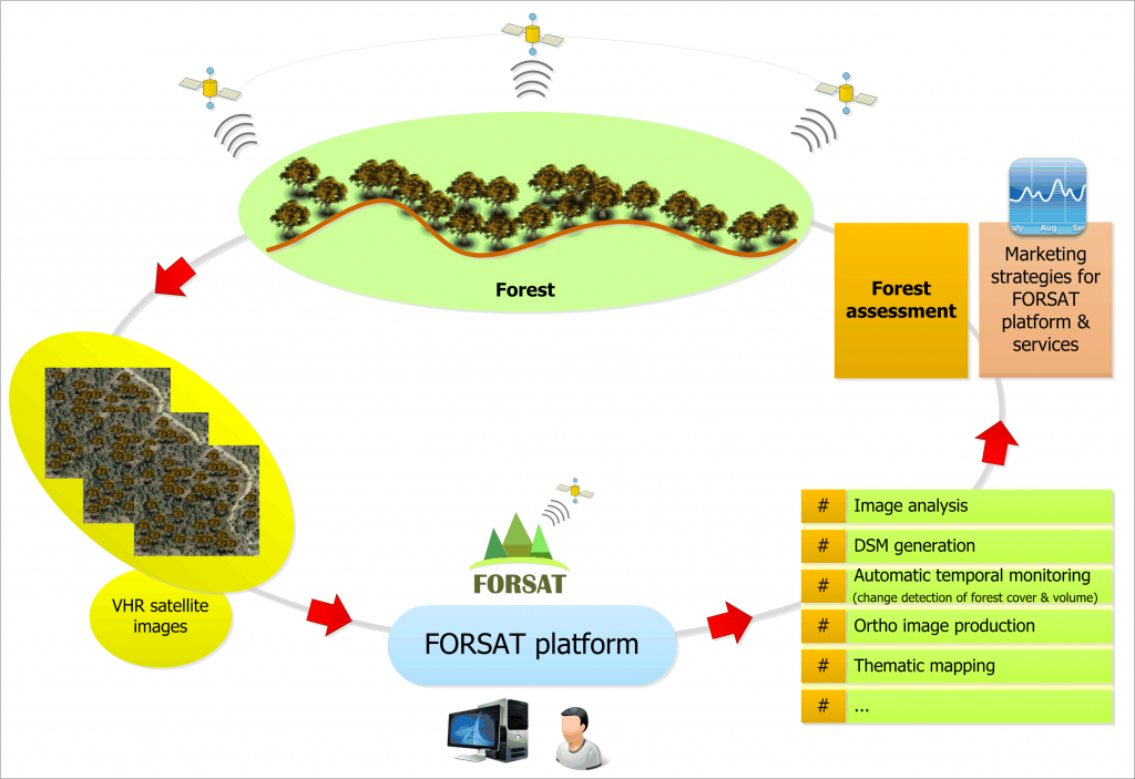
Specifically, the project aspires to transfer the existing precise processing capabilities of airborne techniques to Very High Resolution (VHR) optical, stereographic satellite data, thereby providing a single source forest information solution.
The envisaged FORSAT platform will enable high-resolution thematic mapping of forest areas along with canopy height detection, which will in turn allow for the derivation of forest volume. Based on historical data, the system will allow automatic change detection of forest/non-forest areas along with change in forest volume. The FORSAT functionalities, accuracy, capacities and applicability to specified market segments will be tested, improved and benchmarked against existing relevant platforms.
Project leaders aim to test the capacity and benefits of FORSAT with European users in Austria, Cyprus, Greece, Spain, Switzerland and Turkey by executing six application case studies. This is designed to generate the necessary facts and needed trust of other public bodies and private organizations to use VHR satellite data for many forest information needs, which do not require centimetre accuracy.
Finally, the project shall develop the marketing strategies and business agreements among the partners (and future service providers) for the sale of the FORSAT platform and the accompanying services.
Objectives
In summary, the specific objectives of the proposed project FORSAT are to:
- Develop and validate a VHR satellite imagery-based processing suite and dedicated application solutions products (FORSAT 3D software suite and FORSAT 3D Forest Geo-Products)
- Test user-required applications with viability for future operation and prospect for wider service uptake to the European market
- Set the business framework and promote the developed capacity to provide VHR satellite-based forest assessment solutions.
The results of FORSAT will provide single source, flexible forest information solutions with a competitive price/quality ratio, allowing for new market entry in the forest sector. The project is conceived as a fully user-driven project and the consortium setup ensures know-how transfer between the European Earth Observation (EO) software development and service application industry.
Services & Solutions
The project outcomes are a VHR satellite image processing suite (FORSAT 3D software suite) and the resulting outputs which can be produced and offered by the service providers as standalone products (FORSAT 3D Forest Geo-Products). FORSAT will allow analyzing raw satellite imagery and extract meaningful and quantitative information about the world’s forests, such as area, volume and measurements of deforestation or even regeneration of a forest. FORSAT will offer to different organization access to a high-performance satellite imagery-processing platform.
Combining high resolution massive data from images and technology resources through FORSAT platform offers the following advantages:
- Unprecedented speed,
- Ease of use and lower costs,
- Security, privacy and transparency,
- Climate change impact.
Technologies
FORSAT 3D software suite is specialized in forest monitoring and deforestation detection with generation of precise and dense digital surface models using the multi-temporal high resolution satellite imagery. The system will operate purely in 3D space both in terms of modelling and change detection aspects. It will deal with 3D canopy height models (CHM) as the basic temporal layer. These data layers will be compared with truly 3D methods. Thus, the monitoring system will detect not only the change of forest / non-forest area but also the change of the canopy volume.
All these functionalities will be bound with a modular and object-oriented software architecture.