FORSAT consists of modules for the geometric and radiometric processing of satellite HR (high resolution) and VHR (very-high resolution) imagery from optical sensors, 2D/3D information extraction and 3D change analysis.
FORSAT allows you to:
- Handle satellite images and measure image and ground points with manual and semi-automated modes;
- Improve geometric sensor orientation;
- Derive quasi-epipolar images for 3D stereo measurements in the images;
- Extract Digital Surface Models (DSMs) by using a precise and robust image matching approach, which was specially designed for HR/VHR satellite imagery;
- Generation of orthoimages;
- Measure 3D information in single images using mono-plotting;
- Extract 2D and 3D objects;
- Import digital elevation models, align them using advanced 3D surface matching approach and calculate the 3D differences between them.
- Evaluate changes in surface models.
FORSAT supports most of the HR and VHR optically imagery commonly used for civil applications: IKONOS, OrbView – 3, SPOT – 5 HRS, SPOT – 5 HRG, QuickBird, GeoEye-1, WorldView-1/2, Pléiades 1A/1B, and sensors of similar type to be expected in the future.
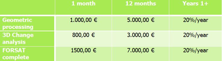
The following business models and pricing policy for the FORSAT platform are available.
Application & Services
FORSAT consortium offers the following professional services:
- Sale of FORSAT full licenses or partial licenses.
- Extraction of 3D geometric information and automatic change detection from HR (high resolution) and VHR (very-high resolution) imagery from satellite optical sensors.
- The first unit that is dedicated to the geometric and radiometric processing of satellite optical imagery and 2D/3D information extraction, like: image radiometric pre-processing, image and ground point measurement, improvement of geometric sensor orientation, quasi-epipolar image derivation for 3D stereo measurements; digital Surface Models (DSMs) extraction by using a precise and robust image matching approach specially designed for HR/VHR satellite imagery; generation of orthoimages; 3D information measurement in single images using mono-plotting and in stereo images. FORSAT supports most of the HR and VHR optically imagery commonly used for civil applications: IKONOS, OrbView – 3, SPOT – 5 HRS, SPOT – 5 HRG, QuickBird, GeoEye-1, WorldView-1/2, Pléiades 1A/1B, and sensors of similar type to be expected in the future.
- The second unit of FORSAT which is dedicated to 3D surface comparison for change detection. The sub-modules allow users to import Digital Elevation Models (DEMs), align them using advanced 3D surface matching approach and calculate the 3D differences and volume changes between two epochs.
- Can be considered a single source and flexible forest information solution with a very competitive price/quality ratio, allowing expert and non-expert remote sensing users to monitor forests in three and four dimensions from HR and VHR optical imagery for many forest information needs, which do not require centimeter accuracy.
- Software support;
- Data processing. The consortium has the competency to acquire satellite images based on the clients’ needs, process them to extract 3D information and perform 3D change analysis.
- Consultancy in remote sensing, photogrammetry, geo-informatics and web-based geospatial applications.